|
pavi
0.0
Map Path Viewer
|


|
|
pavi
0.0
Map Path Viewer
|
|
Welcome to project PaVi, an application to view GPS tracks on top of map tiles, based on library OsmGpsMap, which can download, cache and render map tiles from different web sources. As of now coding and testing gets done with tracks recorded by MapFactor Navigator software in *.NMEA and *.GPX file format.
Find detailed information on components at
The package is hosted at GitHub. Find further information on this project at the projects introduction page and in the online documentation.
It's a GPLv3 licensed GtkApplication with grafical user interface, command line control and DBus integration, designed to:
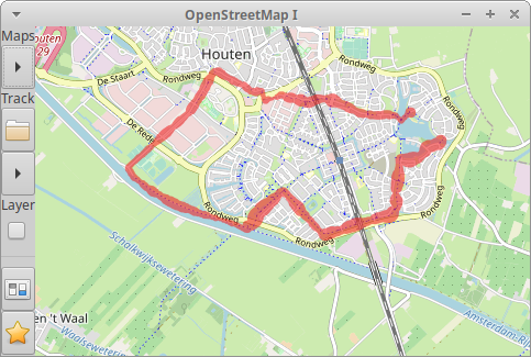
*.NMEA or *.GPX file format)The following screen shot shows a track ploted (by cairo) on top of OSM (Open Stree Map) map tiles by red points (60 % translucent) with variable diameter (scaled by the points elevation):
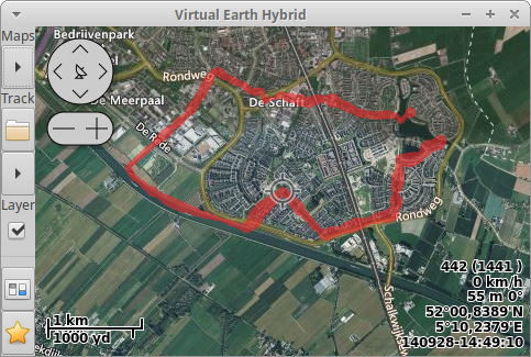
The second screen shot plots the same track on top of Virtual Earth Hybrid map tiles, complemented by a layer providing controls and point info:
Currently this project is work in progress in an early stage. Planed future improvements are:
GPLv3: Copyright (C) 2021, Thomas{ doT ]Freiherr[ At ]gmx[ DoT }net
This bundle is free software; you can redistribute the sources and/or modify them under the terms of the GNU General Public License version 3 as published by the Free Software Foundation.
The programs are distributed in the hope that they will be useful, but WITHOUT ANY WARRANTY; without even the implied warranty of MERCHANTABILITY or FITNESS FOR A PARTICULAR PURPOSE. See the GNU General Public License for more details.
You should have received a copy of the GNU General Public License along with this program; if not, write to the Free Software Foundation, Inc., 51 Franklin Street, Fifth Floor, Boston, MA 02110- 1301, USA. Or refer to http://www.gnu.org/licenses/gpl-3.0.html
 1.8.17