|
pavi
0.0
Map Path Viewer
|


|
|
pavi
0.0
Map Path Viewer
|
|
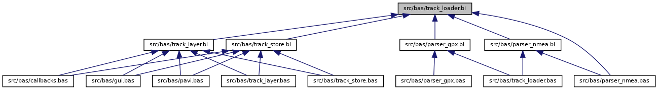
Header for TrackLoader,loading track files. More...
Go to the source code of this file.
Classes | |
| class | TrP |
| Data for a single track point. More... | |
| class | TrackLoader |
| UDT collecting and holding the track data. More... | |
Typedefs | |
| typedef single | float |
Functions | |
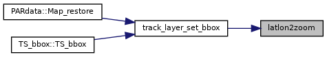
| FUNCTION_AS_LONG | latlon2zoom (BYVAL_AS_LONG, BYVAL_AS_LONG, BYVAL_AS_float, BYVAL_AS_float, BYVAL_AS_float, BYVAL_AS_float) |
| Evaluate the matching zoom level for BBox. More... | |
Variables | |
| const DOUBLE | NaN = 0.0/0.0 |
| Not a number (error value) More... | |
| const DOUBLE | LN2 = LOG(2) |
| natural logarythm 2.0 More... | |
| const DOUBLE | PI = 4 * atn(1) |
| PI = 3.14... More... | |
| const DOUBLE | PIx2 = PI * 2 |
| PI * 2. More... | |
| const DOUBLE | PId2 = PI / 2 |
| PI * 2. More... | |
| const DOUBLE | Deg2Rad = PI / 180 |
| transform degree in radians More... | |
| const DOUBLE | Rad2Deg = 180 / PI |
| transform radians in degree More... | |
| const DOUBLE | ERA = 3443.89849 * 1852 |
| earth radius [m] More... | |
Header for TrackLoader,loading track files.
The TrackLoader class (UDT) is designed to load and analyse track files (*.NMEA and *.GPX, generated by MapFactor Navigator software). Individual parsers can get invoked in order to load different file formats.
Definition in file track_loader.bi.
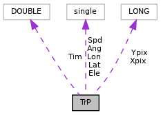
| class TrP |
Data for a single track point.
UDT used to store the point data graped from the file. Undefined values get stored as NaN entries. The LONG values [XY]pix gets computed later for the current map zoom level.
Definition at line 32 of file track_loader.bi.
| Class Members | ||
|---|---|---|
| DOUBLE | Tim | Date / Time. |
| float | Lat | Latitude. |
| float | Lon | Longitude. |
| float | Ele | Elevation [m]. |
| float | Spd | Speed over ground [km/h]. |
| float | Ang | Direction Angle. |
| LONG | Xpix | world X pixel for ploting |
| LONG | Ypix | world Y pixel for ploting |
| typedef single float |
Definition at line 12 of file track_loader.bi.
| FUNCTION_AS_LONG latlon2zoom | ( | BYVAL_AS_LONG | W, |
| BYVAL_AS_LONG | H, | ||
| BYVAL_AS_float | La0, | ||
| BYVAL_AS_float | La1, | ||
| BYVAL_AS_float | Lo0, | ||
| BYVAL_AS_float | Lo1 | ||
| ) |
Evaluate the matching zoom level for BBox.
| W | Width of map widget |
| H | Height of map widget |
| La0 | Minimum latitude |
| La1 | Maximum latitude |
| Lo0 | Minimum longitude |
| Lo1 | Maximum longitude |
This function evaluates the zoom level for the map in order to show a bounding box completely on the map.
Definition at line 116 of file track_loader.bas.
| const DOUBLE NaN = 0.0/0.0 |
Not a number (error value)
Definition at line 15 of file track_loader.bi.
| const DOUBLE LN2 = LOG(2) |
natural logarythm 2.0
Definition at line 16 of file track_loader.bi.
| const DOUBLE PI = 4 * atn(1) |
PI = 3.14...
Definition at line 17 of file track_loader.bi.
| const DOUBLE PIx2 = PI * 2 |
PI * 2.
Definition at line 18 of file track_loader.bi.
| const DOUBLE PId2 = PI / 2 |
PI * 2.
Definition at line 19 of file track_loader.bi.
| const DOUBLE Deg2Rad = PI / 180 |
transform degree in radians
Definition at line 20 of file track_loader.bi.
| const DOUBLE Rad2Deg = 180 / PI |
transform radians in degree
Definition at line 21 of file track_loader.bi.
| const DOUBLE ERA = 3443.89849 * 1852 |
earth radius [m]
Definition at line 22 of file track_loader.bi.
 1.8.17